Explore the best places
Country in Portugal
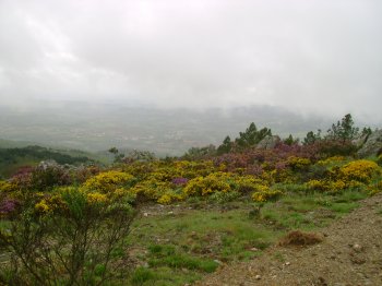
Serra de Montemuro
- country
Serra de Montemuro
4690, Alhões
It lies between the Douro River to the north and the Paiva River to the south, bordering the city of Lamego. The highest point of the mountain range is called Montemuro, at 1,381 meters above sea level. The entire mountain range is quite steep and steep on practically all sides. The mountain range is populated up to approximately 1,100 meters above sea level, with villages scattered throughout, but almost always near watercourses. The Varosa River (which separates it from the Leomil Mountains) and the Balsemão River originate in this range. The Paiva River separates it from the Arada Mountains. It …
Parque Icnológico de Penha Garcia
- country
Penha Garcia
6060, Idanha-a-Nova
Here you can see rock formations containing fossils of prehistoric creatures, some over 480 million years old. This site is part of the "Fossil Trail" hiking trail.
Parque Natural do Tejo Internacional
- country
Segura
6060-521, Segura
The park encompasses the municipalities of Castelo Branco and Idanha-a-Nova and is home to a natural heritage of exceptional value. The enclosed valleys of the Tagus River, its tributaries (Erges, Ponsul, and Aravil), and the adjacent flatlands establish the transition between the Central Mountain Range and the Alentejo plain. The climate is typically Mediterranean and is dominated by a rural landscape of extensive crops and cork oak and holm oak forests. But it is above all the transitions between the different landscape types and the mosaics created by these transitions that give the International Tagus Natural Park its unique color, …
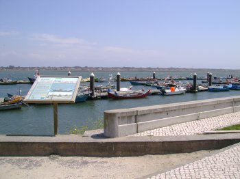
Percurso Pedestre Entre a Ria e o Mar (PR1)
- country
Ílhavo
3830, Costa Nova do Prado
A circular trail that is about 11.5 km long, along the seashore sand dunes. There are panels about the fauna, the flora and the geology. The second part of the trail crosses the villages of Costa Nova do Prado and of the Praia da Barra.
Serra de Bornes
- country
Serra de Bornes
5340, Olmos
It belongs to the Old Massif and is located in the east-central region of Trás-os-Montes, between the Sabor and Tua rivers. It is over 12 km long and 5 km wide, reaching its highest point at 1,200 meters, above the Vilariça valley. The region is characterized by mountain ranges, small high-altitude plateaus, deep, hollow valleys, some watercourses, and open valleys. The flora ranges from chestnut trees to cork oaks, olive trees, almond trees, cherry trees, orange trees, and vineyards. It is noteworthy that, until a few years ago, rye was cultivated at an altitude of about 1,000 meters.
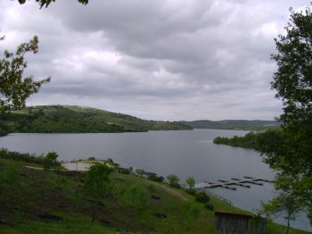
Paisagem Protegida da Albufeira do Azibo
- country
Albufeira do Azibo
5340, Santa Combinha
The Azibo Reservoir, originating from the dam, has a surrounding area of regional scope that is protected for its rich fauna and flora.
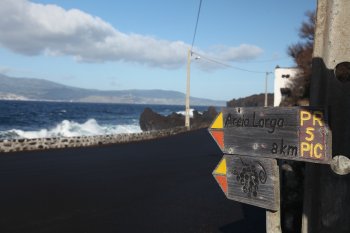
Trilho Pedestre Vinhas da Criação Velha (PR5)
- country
Criação Velha
9950-154, Madalena
The trail follows the coastline until it reaches a hill, which should be skirted on the right. Then, at the next intersection, it enters the vineyards and continues to the marked mill, a viewpoint offering panoramic views of the vineyards and the Madalena islets.
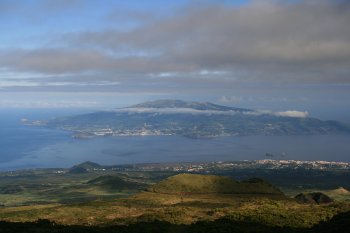
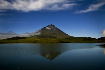
Ponta do Pico
- country
Madalena
9950, Madalena
It is the highest mountain in Portugal, at 2,351 meters, culminating in the crater of Pico Grande, where Pico Pequeno rises, whose base emanates fumaroles. It is classified as a Nature Reserve, and in 2010, its volcanic landscape was named one of the Seven Natural Wonders of Portugal. It is possible to climb it during the summer months with a guide.
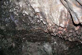
Gruta das Torres
- country
Caminho Rural da Gruta das Torres
9950, Madalena
A volcanic formation, approximately 5,150 meters long, it is the largest known lava tube in Portugal. It was formed by lava ejected from a volcanic eruption in Cabeço Bravo, and today, curious geological structures such as stalactites, lava stalagmites, and lava balls can be seen.
Escalada ao Pico
- country
Cabeço das Cabras
9950, Madalena
Climbing Portugal's highest point is a unique and unforgettable challenge, not within everyone's reach. It's a demanding route, even for those experienced in hiking. The hike begins on the west side of the mountain at approximately 1,230 meters above sea level, at the Pico Mountain House. After providing your information to the Madalena Municipal Fire Department, you can begin the 1,100-meter ascent, along a 4,700-meter route, with an incline that reaches 40° in some spots. From the 2,351-meter summit of Piquinho, it's possible, if the sky is clear, to observe all the islands of the central group and an immense …