in all country Abrantes Águeda Aguiar da Beira Alandroal Albergaria-a-Velha Albufeira Alcácer do Sal Alcanena Alcobaça Alcochete Alcoutim Alenquer Alfândega da Fé Alijó Aljezur Aljustrel Almada Almeida Almeirim Almodôvar Alpiarça Alter do Chão Alvaiázere Alvito Amadora Amarante Amares Anadia Angra do Heroísmo Ansião Arcos de Valdevez Arganil Armamar Arouca Arraiolos Arronches Arruda dos Vinhos Aveiro Avis Azambuja Baião Barcelos Barrancos Barreiro Batalha Beja Belmonte Benavente Bombarral Borba Boticas Braga Bragança Cabeceiras de Basto Cadaval Caldas da Rainha Calheta Calheta de São Jorge Câmara de Lobos Caminha Campo Maior Cantanhede Carrazeda de Ansiães Carregal do Sal Cartaxo Cascais Castanheira de Pêra Castelo Branco Castelo de Paiva Castelo de Vide Castro Daire Castro Marim Castro Verde Celorico da Beira Celorico de Basto Chamusca Chaves Cinfães Coimbra Condeixa-a-Nova Constância Coruche Corvo Covilhã Crato Cuba Elvas Entroncamento Espinho Esposende Estarreja Estremoz Évora Fafe Faro Felgueiras Ferreira do Alentejo Ferreira do Zêzere Figueira da Foz Figueira de Castelo Rodrigo Figueiró dos Vinhos Fornos de Algodres Freixo de Espada à Cinta Fronteira Funchal Fundão Gavião Góis Golegã Gondomar Gouveia Grândola Guarda Guimarães Horta Idanha-a-Nova Ílhavo Lagoa Lagoa Lagos Lajes das Flores Lajes do Pico Lamego Leiria Lisboa Loulé Loures Lourinhã Lousã Lousada Mação Macedo de Cavaleiros Machico Madalena Mafra Maia Mangualde Manteigas Marco de Canaveses Marinha Grande Marvão Matosinhos Mealhada Mêda Melgaço Mértola Mesão Frio Mira Miranda do Corvo Miranda do Douro Mirandela Mogadouro Moimenta da Beira Moita Monção Monchique Mondim de Basto Monforte Montalegre Montemor-o-Novo Montemor-o-Velho Montijo Mora Mortágua Moura Mourão Murça Murtosa Nazaré Nelas Nisa Nordeste Óbidos Odemira Odivelas Oeiras Oleiros Olhão Oliveira de Azeméis Oliveira de Frades Oliveira do Bairro Oliveira do Hospital Ourém Ourique Ovar Paços de Ferreira Palmela Pampilhosa da Serra Paredes Paredes de Coura Pedrógão Grande Penacova Penafiel Penalva do Castelo Penamacor Penedono Penela Peniche Peso da Régua Pinhel Pombal Ponta Delgada Ponta do Sol Ponte da Barca Ponte de Lima Ponte de Sor Portalegre Portel Portimão Porto Porto de Mós Porto Moniz Porto Santo Póvoa de Lanhoso Póvoa de Varzim Povoação Praia da Vitória Proença-a-Nova Redondo Reguengos de Monsaraz Resende Ribeira Brava Ribeira de Pena Ribeira Grande Rio Maior Sabrosa Sabugal Salvaterra de Magos Santa Comba Dão Santa Cruz Santa Cruz da Graciosa Santa Cruz das Flores Santa Maria da Feira Santa Marta de Penaguião Santana Santarém Santiago do Cacém Santo Tirso São Brás de Alportel São João da Madeira São João da Pesqueira São Pedro do Sul São Roque do Pico São Vicente Sardoal Sátão Seia Seixal Sernancelhe Serpa Sertã Sesimbra Setúbal Sever do Vouga Silves Sines Sintra Sobral de Monte Agraço Soure Sousel Tábua Tabuaço Tarouca Tavira Terras de Bouro Tomar Tondela Torre de Moncorvo Torres Novas Torres Vedras Trancoso Trofa Vagos Vale de Cambra Valença Valongo Valpaços Velas Vendas Novas Viana do Alentejo Viana do Castelo Vidigueira Vieira do Minho Vila de Rei Vila do Bispo Vila do Conde Vila do Porto Vila Flor Vila Franca de Xira Vila Franca do Campo Vila Nova da Barquinha Vila Nova de Cerveira Vila Nova de Famalicão Vila Nova de Foz Côa Vila Nova de Gaia Vila Nova de Paiva Vila Nova de Poiares Vila Pouca de Aguiar Vila Real Vila Real de Santo António Vila Velha de Ródão Vila Verde Vila Viçosa Vimioso Vinhais Viseu Vizela Vouzela
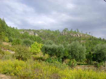
Natural Resources in Proença-a-Nova This mountain range connects Alto Alentejo to Beira Baixa, stretching 27 km and measuring almost 2,500 m wide. Its slopes sometimes exceed 50%. It runs through Proença-a-Nova, Vila Velha de Ródão, and Nisa and is traversed by the deep epigenetic valleys of the Tagus and Ocreza rivers. Four geomonuments of the Naturtejo Geopark of the Southern Plateau can be seen in this mountain range.
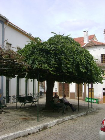
Elm classified as a Living Monument of Public Interest. These trees can reach up to 30 meters in height, and their flowers, though scarce, can produce nuts. The wood from this type of tree is often highly sought after for making furniture, carpentry, or naval purposes.
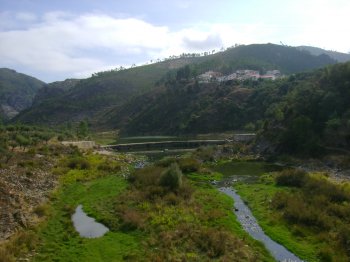
A tributary of the Tagus river right bank that starts on the Gardunha Hill, at an altitude of 1227 metres, in Castelo Branco. It has an estuary with 83 km and its mouth at Vila Velha de Rodão.
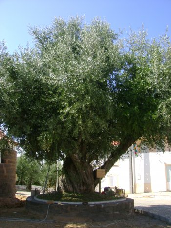
A Living Monument of Public Interest, because it is a centennial tree. The olive tree is a regional symbol. This tree may be around 800 years old.
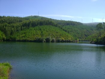
A dam on the Isna brook, a tributary of the left bank of the Zêzere river, on the Tagus river basin. It is surrounded by pine trees and farmlands. Fishing is allowed.